Edge Scout TAK plugin · user guide
The plugin,
end to end.
Everything the plugin does, in the order you will meet it: install it, link a sensor, work a detection, and configure the alerts. Written for the operator holding the tablet.
Overview
What the plugin does
The plugin listens for drone Remote ID broadcasts and draws them on your TAK map in real time, on the screen your team already works from.
- Individual airframe tracking — one drone, one track
- Track freshness, with visible aging and fade-out
- Pilot location plotted and tethered to the drone
- Nearby crewed aircraft via ADS-B, where your sensor supports it
Requirements
What you need
- An Android EUD running ATAK-CIV 5.5 or later
- The Edge Scout plugin, version-matched to that ATAK release
- An Edge Scout sensor — mini, mini-c, Charlie, Link, Pro or Tower
- A connection: Bluetooth, USB-C tether, or your TAK Server via the Edge Scout TAK Bridge
Setup
Install and enable
- 01 Install ATAK. Install ATAK-CIV from the Google Play Store if it is not already on the device.
- 02 Install the plugin. From the Play Store, or directly from Nine Hill as an APK for locked-down devices.
- 03 Load it in ATAK. Settings → Tool Preferences → Plugins (Plugins manager) and enable Edge Scout.
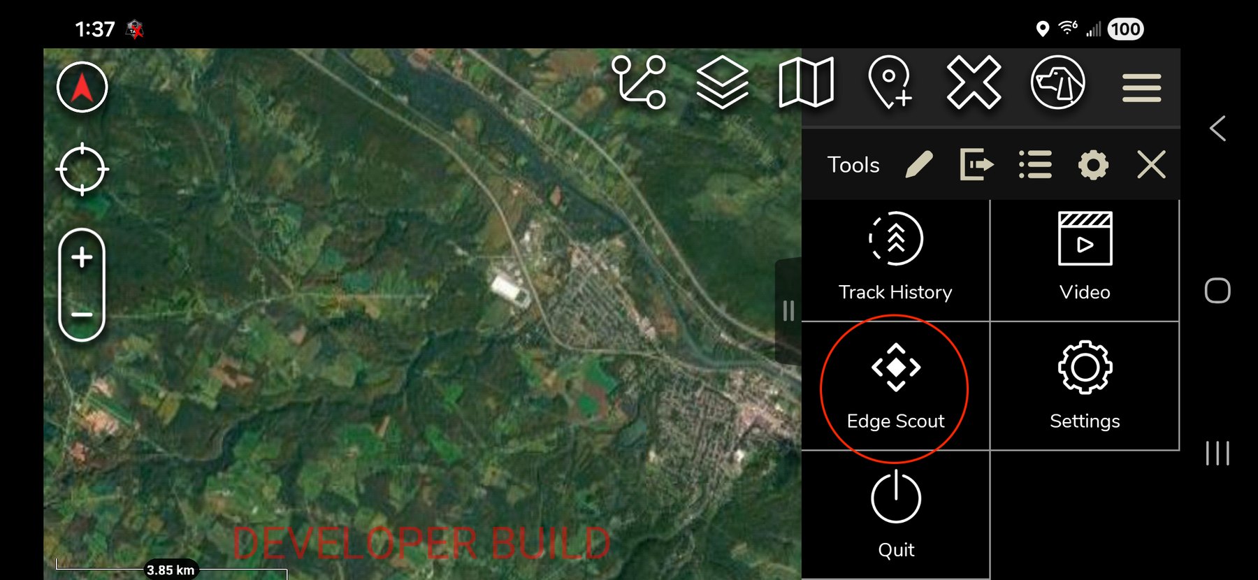
- 04 Open it. Tap the Edge Scout icon in the ATAK toolbar. The plugin opens as a side pane and the map stays live behind it.
Core task
Connecting a sensor
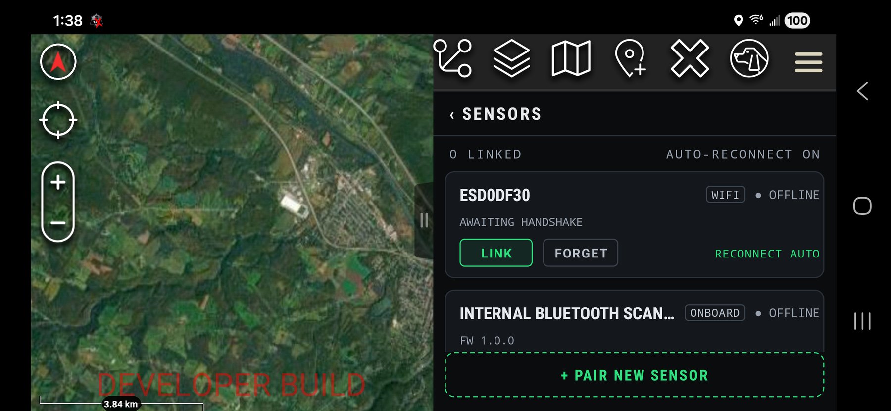
Open SENSORS from the MANAGE › link in the track-list footer.
Over USB-C
Connect the sensor to the EUD with a USB-C cable and approve the one-time Android USB permission prompt. The sensor links automatically, shows as LINKED, and begins feeding tracks.
Over Bluetooth
- 01 Scan. Tap + PAIR NEW SENSOR. Nearby Edge Scouts are listed strongest signal first.
- 02 Link. Tap LINK on the sensor you want, and confirm pairing if prompted.
- 03 Done. Once linked it reconnects by itself on the next session.
From your TAK Server
Link and Tower never pair to a tablet. Their detections reach you through the Edge Scout TAK Bridge, which feeds your TAK Server from Edge View — the plugin then displays them like any other track, with no sensor attached to the device.
Sensor controls
| Control | What it does |
|---|---|
| LINK / UNLINK | Connect or disconnect. Unlinking keeps the card so you can relink quickly. |
| FORGET | Remove a remembered sensor entirely. |
| RECONNECT AUTO / MANUAL | Whether the sensor reconnects itself each session. |
| Transport badge | Shows BT, USB or ONBOARD. |
| Health line | Battery %, signal (RSSI), firmware version, and the feeds available. |
Quick start
The thirty-second workflow
- 01 Detect. A new drone appears in the list and on the map. If alerts are on you get a tone and a buzz. New tracks start as UNKNOWN (yellow).
- 02 Triage. The list sorts by threat. Tap a filter chip to focus on one classification.
- 03 Assess. Tap the track for its detail view: full ID, pilot location, distance and closing rate.
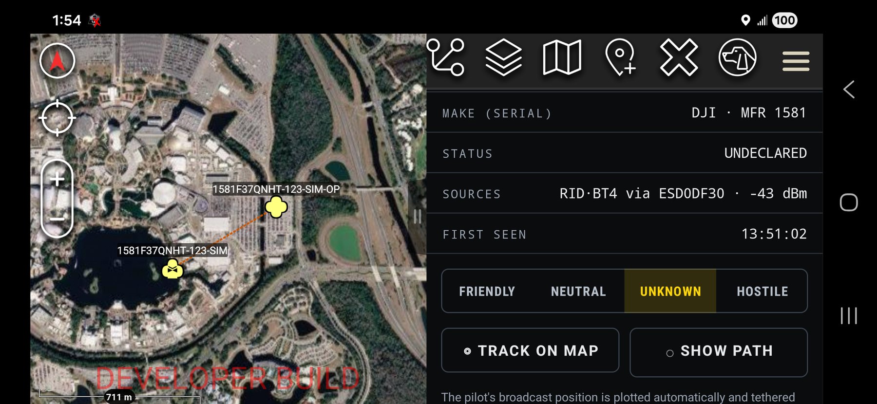
- 04 Classify. One tap marks it FRIENDLY, NEUTRAL, UNKNOWN or HOSTILE. It recolors everywhere and broadcasts to your team.
- 05 Act. The pilot marker is already on the map, tethered to the drone. Navigate to it, hand it off, or keep watching.
Reference
The track list
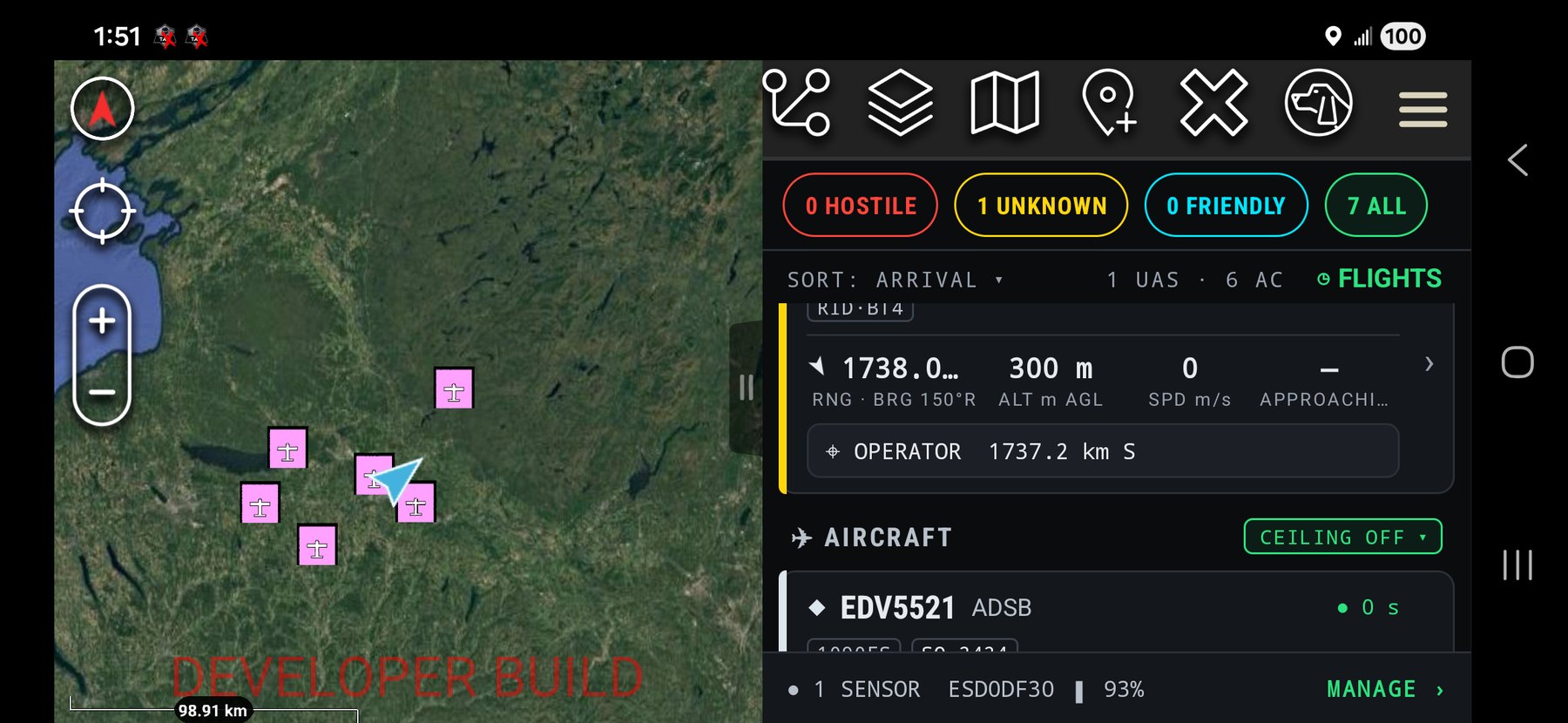
Filter chips
HOSTILE, UNKNOWN, FRIENDLY, ALL — each carries a live count and filters the list. Counts include stale and altitude-hidden tracks.
Sort row
SORT: THREAT ▾ cycles THREAT, RANGE and AGE. The right side shows drone and aircraft counts. ◷ FLIGHTS opens flight history.
What a track card tells you
| Cell | Drone | Aircraft |
|---|---|---|
| Where is it? | Arrow, range and bearing | Same |
| How high? | Metres AGL | Feet MSL |
| How fast? | m/s | Knots (GS) |
| Where is it going? | APPROACHING (red) / RECEDING, m/s | Climb or descent, fpm |
A colored edge bar and diamond show affiliation. The header carries a stable name, the decoded model and a badge per RF source; a freshness dot and age in seconds sit on the right. The operator row reads like ⎈ OPERATOR 320 m NE, or NO FIX when the aircraft is not broadcasting one.
Staleness and the altitude ceiling
A track that stops broadcasting fades, freezes its last numbers and shows a STALE tag. If it stays silent past your Stale-Out Time it drops off the list. Crewed aircraft appear under ✈ AIRCRAFT; tap the green chip to cycle 3,000 / 5,000 / 10,000 ft / OFF. Traffic above the ceiling collapses into an N hidden — SHOW line. Emergency squawks always punch through.
Reference
Track details and the map
Track details
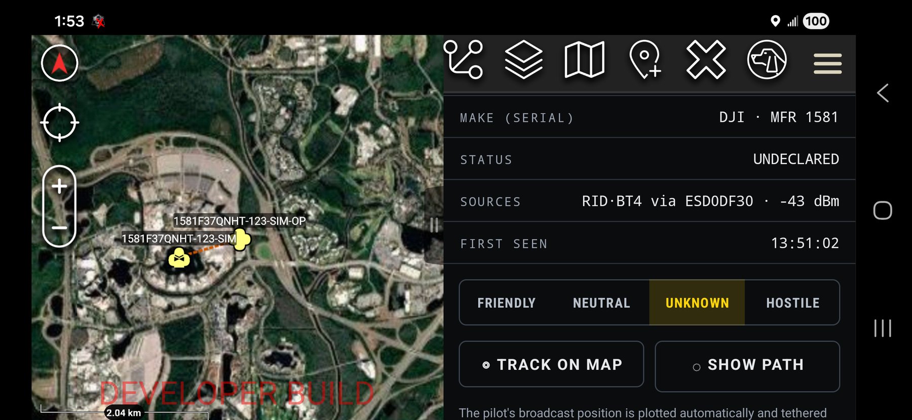
Tap any card. You get an affiliation banner with live evidence (sources and age), three hero numbers — range and bearing, height, closing rate with a time-to-closest-approach countdown when converging — and the full payload: MAC/ID, serial, operator ID, operator position and accuracy, inferred make, RSSI and status.
- Classifier — four-way; one tap recolors the card and map icon and rebroadcasts to the team
- ✎ Rename — a friendly name that persists everywhere
- ◎ TRACK ON MAP — pan and zoom to the target
- ◌ SHOW PATH — draw the flight path as a real TAK route, selectable and exportable; tap again to hide
On the map
Markers match the card color. A leader line scaled to speed shows heading. A dashed burnt-orange tether links the drone to its pilot marker. Markers dim as tracks go stale. Tapping a drone icon and choosing details from the radial menu jumps back into the plugin.
Reference
Flight history
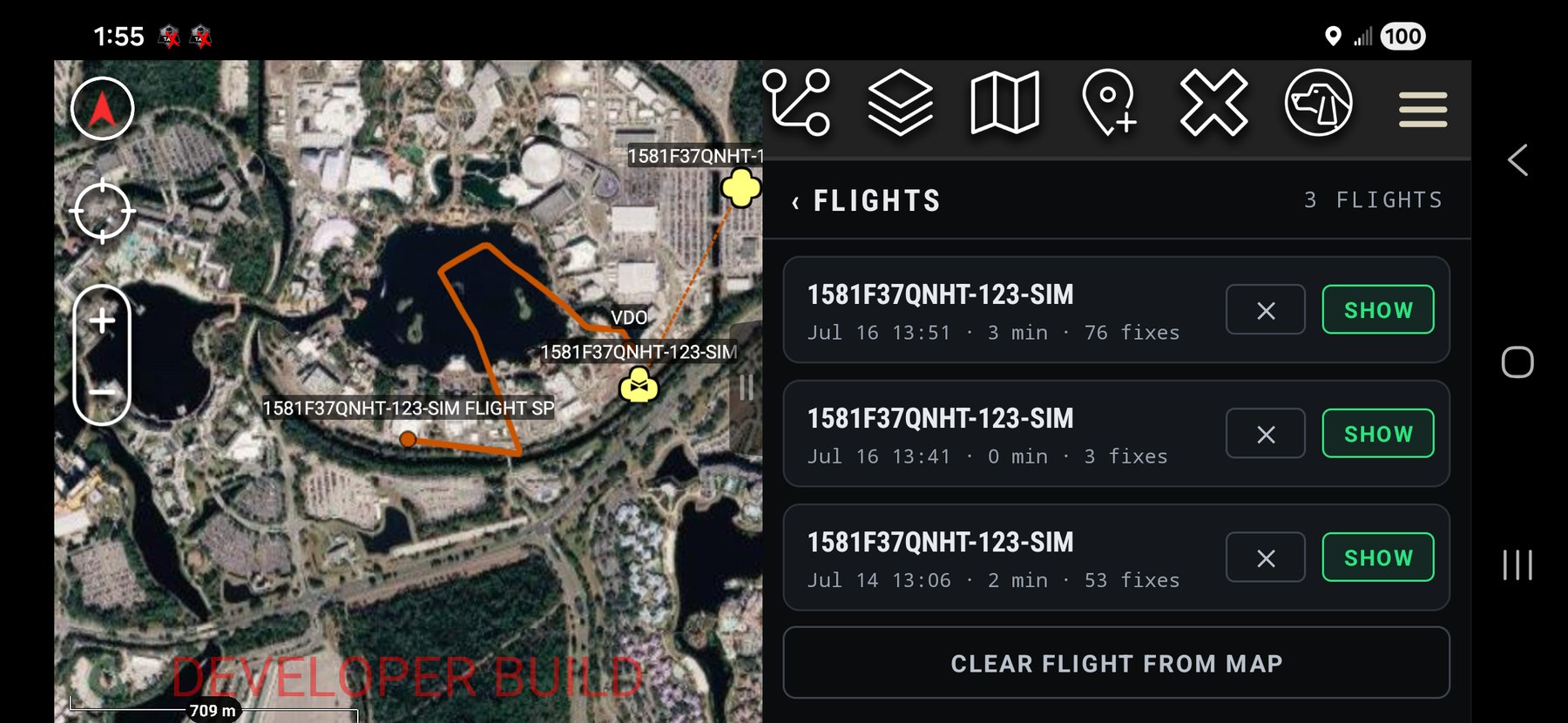
Open ◷ FLIGHTS from the sort row — flights are saved automatically when a drone drops off. SHOW replays the path with the pilot position for that flight, one at a time; CLEAR FLIGHT FROM MAP removes the replay; ✕ deletes it, with a confirmation. Tap ‹ FLIGHTS to go back.
Configure
Alerts and settings
Settings → Tool Preferences → Edge Scout.
| Setting | What it does |
|---|---|
| Audible Alert on New Track | Plays a tone on first detection. |
| Vibrate on New Track | Buzzes on first detection — readable through a pocket. |
| Suppress Alerts for Known Traffic | Stays quiet for civil ADS-B and friendly or whitelisted drones. Hostile and unknown always alert. |
| Aircraft Altitude Ceiling (ft MSL) | Default ceiling for the aircraft section; changeable live from the green chip. |
| Stale Out Time | Seconds after the last broadcast before a track goes stale and is retired. Also defines flight boundaries. |
| Auto Broadcast Found UAS | Shares detections to your TAK servers and multicast automatically. |
| Stolen Drone API Key | Optional. Looks up lost and stolen airframes and auto-flags matches as hostile. |
Sharing over TAK
With Auto Broadcast on, every track you detect and every classification you make goes out over your connected TAK server and multicast. Drones detected by other Edge Scout operators on your network appear in your list and on your map, merged by airframe, so you never see the same drone twice.
Reference
The color language
| Color | Meaning |
|---|---|
| Red | Hostile — a declared threat |
| Yellow | Unknown — the default for a new track |
| Cyan | Friendly — yours, or whitelisted |
| White | Neutral — ordinary civil air traffic |
| Green | Controls — buttons, links, selection, the fresh dot |
| Burnt orange | Paths and tethers — flight-path routes and the pilot tether |
Help
When it doesn’t work
- The plugin doesn’t appear in ATAK
- Fully close and reopen ATAK after installing — plugins are only discovered at startup. Then confirm Edge Scout is enabled in the Plugins manager. If it still will not load, the plugin build has to match your ATAK version; this one is built against ATAK-CIV 5.5.
- The sensor won’t connect over USB
- Check you approved the Android USB permission prompt when the cable went in. If nothing happened, unplug and replug, or open the SENSORS screen. A different USB-C cable — a data cable, not a charge-only one — fixes most of the rest.
- The sensor is linked but no drones show up
- The footer should show the sensor as LINKED and the list should read “LISTENING — TRACKS APPEAR AS THEY ARE HEARD.” If so, there may simply be nothing broadcasting nearby. Only aircraft actively broadcasting Remote ID can be detected.
- A drone shows but there’s no pilot location
- The operator row reads NO FIX until the aircraft broadcasts an operator position. Many send it shortly after take-off once they have GPS lock, so give it a moment and it usually fills in.
- I’m not hearing or feeling alerts
- Check Audible Alert and Vibrate are enabled, and that Suppress Alerts for Known Traffic is not hiding cues for friendly or known contacts. The tone plays on the media channel, so raise media volume. Alerts fire on a track’s first detection only, not on every update.